Y. Mohan Reddy1, and K. T. Ilayarajaa2
1M.E–Embedded System, Sathyabama University, Chennai, India. 2Assistant Professor- Department of ECE, Sathyabama University, Chennai, India
DOI : https://dx.doi.org/10.13005/bpj/616
Abstract
Global Positioning System (GPS) devices are useful for location tracking applications, where these devices act as a receiver with satellite transmitting the location data and the receiver goes for trilateration technique for pointing out the precise device location. This process requires the devices to be tuned to precision. In commercial development and testing of GPS systems or devices, it’s extremely necessary to have testing equipment so as to test the under development GPS devices at lower price and also with minimum labour and ease. The newly developed GPS devices need to undergo a precision test, to know how precisely these devices can locate the location, their speed of operation, one way of obtaining the result is to go for real time testing with the device take around the place and pointing to the open sky to know how perfectly the device model is working, this type of testing always calls for lot of labour, cost and not feasible most of the time. Our proposed idea suggests a virtual simulation of the GPS devices, where a combination of software and hardware model is used for testing of GPS devices. This type of technique does the same task of real time testing but without the device been taken around, this makes the testing cost effective, easy, labour free and feasible at all conditions in the laboratory.
Keywords
Global Positioning; devices; Transmission;
Download this article as:| Copy the following to cite this article: Reddy Y. M, Ilayarajaa K. T. Virtual GPS Simulation Using RF Transmission. Biomed Pharmacol J 2015;8(1) |
| Copy the following to cite this URL: Reddy Y. M, Ilayarajaa K. T. Virtual GPS Simulation Using RF Transmission. Biomed Pharmacol J 2015;8(1). Available from: http://biomedpharmajournal.org/?p=1305 |
Introduction:
Global Positioning System (GPS)is a navigation system based on satellite that provides location information across the earth where there is a line of sight to four or more GPS satellites, the GPS technology is used for military, commercially and civil applications. The GPS device uses a mathematical concept of trilateration, in which the device asks for at least a minimum of 3 satellites data to give the precise location information. To understand a GPS simulator working, it is required to understand some of the details of working of the GPS transmissions and the transmission frame format. The GPS system be consistent with of at least 24 satellites, encircling every 12 hours, broadcasting navigation data on various frequencies. GPS is just one of distinct global navigation satellite systems (GNSS) in action, or soon to be in movement. Almost all the applications on navigation currently use the L1 frequency of GPS at the radio frequency of 1575.42 MHz onto this carrier frequency, satellites transmit a navigation message and identification information that involved synchronized time, the satellite’s recurring data (ephemeris) and data on the familiar positions of all the satellites in the circumstances. From this data that receivers can accurately measure its distance from various satellite signals at the same time to attain its navigation solution through trilateration.
Data transmitted from the satellite:
- Date/Time (by using atomic clock used in the satellite)
- Satellite ID (pseudo random number)
- Ephemeris and almanac
Receiver interpretation:
- Number of satellite signals
- Power level
- Atmospheric and antenna blunders through models
- Multi-path conditions
Receiver position calculation:
- Start position (longitude, latitude and elevation)
- Trajectory (action path)
GPS simulators generate radio frequency that they are adequate of transmitting the exact data as GPS satellites. But the GPS simulator has the capacity to switch an ample variety of parameters right from the test bench. The satellite transmits the data in the frame format( as shown in fig:1), which has a main frame in which 5 sub-frames containing different satellite data are sent in encoded format. This is received at the receiver end which is a GPS device, which decodes and uses the information to calculate the location information of the device.
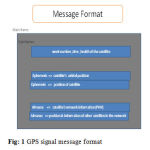 |
Figure 1: GPS signal message format |
While there are various methods to test GPS-based navigation,position and timing functions of the integrated GPS receivers, simulation offers the most resilience, compared to testing with live signals (original signals from the satellite), or record and replay solutions. The simulation gives the testing engineer or developer complete command over the generation of GPS signals.Thishelps to admit confidence in one’s hardware and software’s ability to perform under any condition. For anyone developing a GPS device, the capability to test it with accuracy and repeat ability will shorten development time, and reduce cost. Regardless what market a current GPS product is proposed at or the components that it consists of testing will be essential. Signal recovery, detention, and performance in changing environments, are all key aspects in determining how lucrative a modern device might be.It isn’t always suitable to simply go outside in the open sky to obtain satellite lock, and declare the test procedure as completed because this will not always be the environment or conditions to which the device will be subjected to in day to day applications, it may be subjected to multipath obscuration, interference or reflection, so understanding in these situations how a device will perform is critical. However, recommending these parameters into a ‘real word’ testing method may be totally impractical and will have a large impact on the amount of time it consumes to deliver the product to market. A GPS simulator gives the developer a number of choice. The most definitething is that of being able to input RF satellite signals directly into GPS equipment in the bounds of the lab or office, without experimenting outdoors, makes testing simple and easier.
Proposal
The system proposed in this paper uses the virtual GPS concept. Here we are using virtual GPS system instead of actual GPS satellite system.
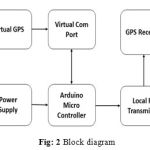 |
Figure 2: Block diagram |
Software simulation
The method gave us the hardware free solution which is definitely a cost effective, less labour and resources needed path. But complete software simulation though yielded better results but was far from real time simulation, the exact proper functioning of the GPS device was hard to know. The software simulation included the complete given parameters and displayed the result according to the given data, but in actual scenario while transmission over the space in wireless medium there are certain other factors to be considered which are not particularly included in the software design. Though these parameters too can be assigned through software they are far from reality and remain completely virtual, which doesn’t give us the complete confidence on the operation of the device.
Software’sused
Avangardo Virtual GPS Simulator
The GPS Generator PRO application is Software GPS Simulator that is designed for providing assistance in testing, debugging, developing programs and equipment working with the NMEA-0183 protocol. And it also can be used for testing equipment and navigation applications indoor when GPS Signal is not available.This virtual GPS is more efficient when used indoors as it can able to work without visible GPS satellites. Moreover, obtaining the program costs less compared to purchasing a GPS receiver.The program imitates the operation of a GPS receiver and deliver out GPS data (position, speed of relocation,quality of reception, and satellite constellation) based on the NMEA-0183 protocol of chosen version. The GPS simulator can be constructed for getting particular NMEA protocol messages in a particular sequence with a certain frequency.
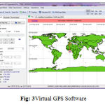 |
Figure 3: Virtual GPS Software |
Arduino Software
The Arduino software is an open source environment which is easy to write code and upload the code to the I/O board. It runs on Mac OS X, Windows, and Linux. The code is written in Java and based on avr-gcc, Processing, and other open source software.
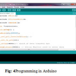 |
Figure 4: Programming in Arduino |
Virtual Com Port
Virtual com port software is used to create a virtual serial communication such that the data from the virtual GPS generator is transmitted to the proteus for simulation purpose.
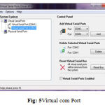 |
Figure 5: Virtual com Port |
Labcenter Electronics Proteus
Proteus is the simulation software, which is used your for simulating the microcontroller for the data transfer of GPS data for the GPS generator.
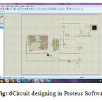 |
Figure 6: Circuit designing in Proteus Software |
Simulation Results
The simulation results shows that the transmitted frequency signal of 1575.45 Mhz received at the receiver end of same 1575.45 MHz The Fig shows the output taken in the virtual oscilloscope.
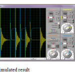 |
Figure 7: simulated result |
Conclusion
The idea of proposed system is undertaken to design a kit for virtual simulation of GPS for GPS receiver development and testing application, a detailed study was undertaken in operation of GPS transmission and reception, and also study was undertaken in existing virtual simulation techniques and its flaws. But the effort was put in to find a way to achieve the result, various techniques of obtaining the desired functionality and software-hardware module was studied with the available resources. Software simulation has been performed and result has been achieved. If continued with the hardware part, on the basis of software simulation the aim of the project can be achieved.
References
- From google source and Wikipedia http://en.wikipedia.org/wiki/Satellite_navigation.
- Misra, P., Enge P. Global Positioning System: Signals, Measurements, and Performance. Ganga-Jamuna Press, Lincoln, Mass., 2011.
- UNITED NATIONS. Current and planned global and regional navigation satellite systems and satellite-based augmentations systems. In International Committee on Global Navigation Satellite Systems Provider’s Forum. New York, June 2010, p. 35-40.
- Several GNSS applications with open source tools GNSS Applications and Methods.
- Parimal Majithiya et. Al. “Indian regional NavigationSatelliteSystem”, [http://www.insidegnss.com/auto/IGM_janfeb11- IRNSS.pdf] For GPS Message format ftp://igscb.jpl.nasa.gov/igscb/data/format/rinex210.txt


